BISAR contains data on a total of 3,864 samples taken at 1,453 stations with 68,433 records of 890 taxa of benthic macrofauna, from 34 artificial structures and surrounding soft bottom collected during 105 cruises between 2003 and 2019 (Table 1).
Data compilation
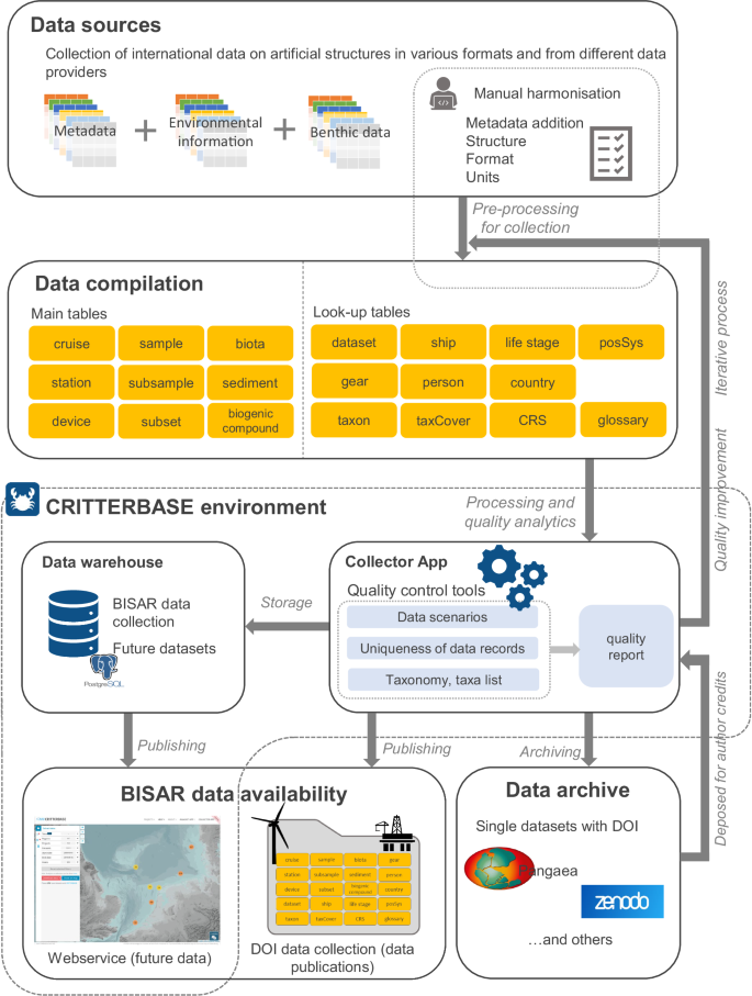
The data were compiled from various sources, such as different international research institutes, universities, and industry. Hence, the format between different datasets varied and the number of metadata was highly variable. To harmonise the data, one data template was created and used by all data providers (Fig. 1, MSExcel-table) containing main tables and metadata information (lookup tables) (see section ‘data records’). The main tables contain metadata on the cruise, station, and individual samples (e.g., scrape samples on turbines) which were compiled for the first time in a harmonised style for the BISAR data collection. Biota data and environmental data (e.g., substrate of samples) were also compiled. Look-up tables collect additional information, e.g., sampling gear and life stages of biota. A glossary of the BISAR data collection provides detailed information about the data columns, as well as units of column data and a brief description.
Each dataset was individually transferred to the BISAR data collection by copying data columns from the original datasheets in the corresponding columns of the multi-sheet format. The compilation of the data was done between the data contributors and experienced data curators in an iterative process until the datasets were combined in the BISAR data collection (Fig. 1).
Notes on benthic sampling
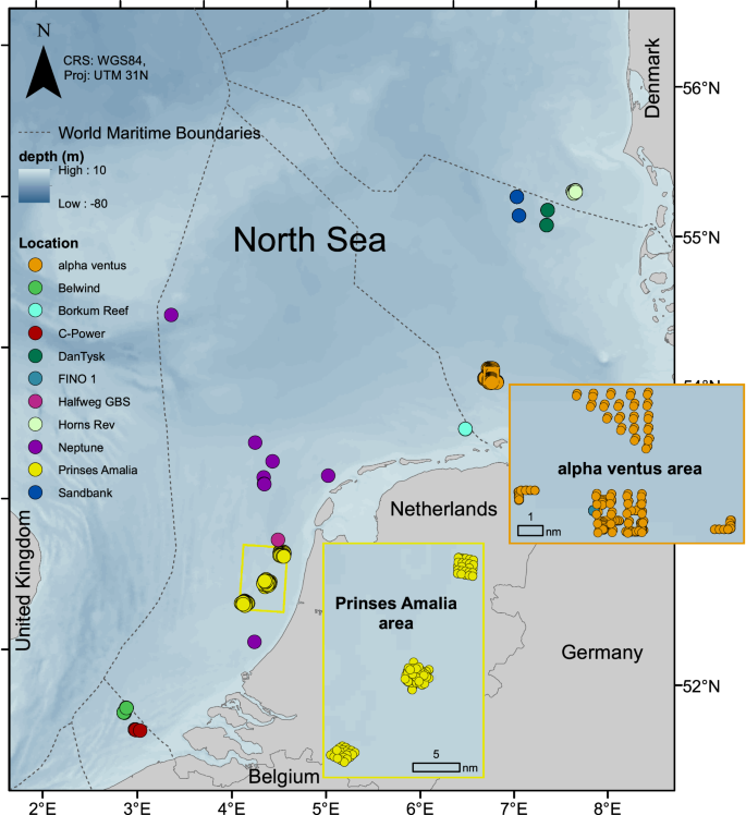
Benthos samples were collected within the different projects which included seven OWFs, nine oil and gas platform foundations, one research platform and one geogenic reef (Fig. 2) in the North Sea. Different methods were applied to collect samples from the hard substrates on and around the artificial structures. Specifics for each artificial structure or platform are described in the following sections.
FINO 1 research platform, Germany
The research platform FINO 1 is similar in size and shape to today’s jacket foundations of offshore wind turbines32. Sampling of the artificial hard substrate took place between April 2005 and October 2007 at nine different water depths between 1 and 28 m. At each depth, one to two samples were taken at random positions on vertical surfaces. Samples measuring 20 × 20 cm were scraped and captured in a mesh bag (mesh size: 0.5 mm) by scientific divers. Aboard all samples were preserved in 4% borax-buffered formalin. In the laboratory, specimens were pre-sorted, stored in 75% ethanol and then identified. Colonial species were counted as present, while individual species were counted and wet weighed. Wet masses were corrected by a factor of 1.2 to account for changes due to storage in ethanol (following Zintzen et al.33,34).
Alpha ventus, Sandbank and DanTysk offshore wind farms, Germany
At alpha ventus, both epifauna communities on the structures and seabed communities (wind farm area and reference area) were sampled. Sandbank and DanTysk were sampled for the fauna colonising the artificial hard substrate. All three datasets were collected according to the standard investigation concept for OWFs in the German part of the North Sea (latest version: StUK 423,35).
Data from alpha ventus were collected in autumn 2009 and spring and autumn in the years 2010–2012. Sandbank was sampled in August 2019 and DanTysk in September 2018 and August 2019. Four turbines were investigated in alpha ventus (i.e., 2 jacket structures, 2 tripods), two turbines in Sandbank and DanTysk (all monopiles). Scrape samples with a surface area of 0.04 m² were collected by scientific divers at three or four different depths (alpha ventus at 1, 5, 10 and 15 m, Sandbank and DanTysk at 1, 5, 10 m), each with three replicates. Organisms were collected in mesh bags with a mesh size of 0.5 mm and conserved in 4% borax-buffered formalin. In the laboratory, taxa were identified, and individuals were counted and wet weighed.
Data from the project StUKplus Benthos also included seabed communities from alpha ventus only (in autumn 2008–2011)36. Samples were taken with Van Veen grabs (surface area 0.1 m²). The dataset served as a complementary investigation to the alpha ventus StUK monitoring, specifically to capture data relating to potential processes occurring at different distances from single wind turbines of the wind farm. Samples were collected at four sites, i.e., at two wind turbines inside the OWF alpha ventus and in two reference areas outside the OWF, with one transect in the main water current direction and one perpendicular to each other. Along each transect, seven stations, each 100 m apart (within OWF) and four sampling stations, each 200 m apart (within reference areas) were sampled. At each station, three replicate Van Veen grabs were sampled. Organisms were sieved over a 1 mm mesh and conserved in 4% borax-buffered formalin. Taxa were identified and individuals were counted and weighed (wet mass) afterwards in the laboratory.
Horns Rev I offshore wind farm, Denmark
In the Horns Rev I wind farm in Denmark, two sampling surveys of epifauna organisms per year were conducted on the monopile foundations and scour protection layer, during three years i.e., March and September of 2003, 2004 and 200537,38. Scrape samples of 0.04 m2 were collected by scientific divers in the direction of the principal water current on both the upstream (SSW) and the downstream sides (NNE). Samples were taken at depths of 0, 2, 4, 6 and 8 m depth at the monopiles and from rocks in the scour protection layer at depths between 6 and 10 m. Two replicates per depth and three per rock were collected in bags with a mesh size of 1 mm. All samples were preserved in ethanol until further processing in the laboratory, where the samples were sorted under a stereomicroscope. All organisms were identified, counted and their ethanol wet mass was determined.
Prinses Amalia wind farm, the Netherlands
In the Prinses Amalia wind farm (PAWP), the fauna both on the structures and in the seabed were studied. In total, four turbine foundations were selected, both at edges and at the centre of the wind farm. Monitoring of the epifauna on the monopile foundations and scour protection layer was conducted three and a half (October 2011) and six (July 2013) years after construction27,39,40. Scrape samples taken by scientific divers were collected at five different depths: splash zone, 2, 5, 10 and 17 m depth from both sides of the turbine (SSW and NNE) with a single sample per depth-side combination. The sampled surface area was 28 × 20 cm (0.056 m2) and scraped fauna were collected in a sampling net (mesh size: 0.25 mm). The scour protection layer was sampled by collecting small rocks.
Soft-sediment fauna was collected within the wind farm in March 2012 and April 201339,40 with 1 sample per station, from the wind farm and reference areas south-west and north-east of the wind farm. Soft sediment fauna was sampled using a box corer grabbing an area of 0.078 m2. The samples were sieved on board on a sieving table with mesh size of 1 mm.
All samples and rocks were fixed with a borax buffered 5% formaldehyde solution. In the laboratory, all organisms were identified, counted and their biomass (both wet and ash-free dry mass) was measured. Colonial species were noted as present per sample, while their biomass was not determined.
Borkum Reef grounds, oil and gas platforms Neptune Energy & Petrogas GBS, the Netherlands
The Borkum Reef Grounds is an area with geogenic reefs at the border between the Netherlands and Germany. Neptune and Petrogas are oil and gas platforms in the Netherlands. The fauna of the geogenic reefs and large hard substrates from platforms were sampled by scientific divers by scraping, using an airlift sampler with nets of mesh size 0.5 mm27,28,41. Sample size was 0.05 m2. On the scour protection layer around the Neptune platforms, individual rocks or gravel were collected from an area of 0.05 m2. Around the Petrogas Gravity Based structure (GBS), large rocks were sampled by scraping fauna from within a 0.05 m2 frame and collecting it in an airlift sampler with nets of mesh size 0.5 mm. On board, samples were rinsed from the nets and conserved on ethanol 99% or borax buffered formaldehyde 6%. Rocks with epifauna were conserved whole without sieving. In the laboratory, all taxa were identified, counted and weighed (all wet, some also ash free dry mass). Colonial species surface area covered was estimated to the nearest cm2, but the species were not weighed.
Belwind and C-Power offshore wind farms, Belgium
The long-term monitoring of Belgian offshore wind farms started in 200842 and is still ongoing. The monitoring data presented here refer to monopile foundations from the Belwind OWF (since 2010), and jacket and gravity-based foundations from the C-Power park (since 2008). During the first two years, the sampling occurred seasonally (spring, summer, autumn) and across various depths of the selected foundations. Later, the samples were collected once a year in summer or autumn, at approximately 15 m depth and from the scour protection layers. In Belwind, four monopile foundations were sampled throughout the monitoring period, but not simultaneously. In C-Power, the gravity-based turbine D5 was sampled throughout the entire duration of the monitoring, except in 2016 when samples were taken from D6. The jacket foundation from C-Power was sampled only once (one year after installation). The sample size of the scrape samples taken by scientific divers was 0.0625 m2 and scraped material was collected in a plastic zip lock bag. Scour protection layer stones were collected manually by divers and were brought to the surface in plastic sample bags. All samples were preserved in buffered 4% formalin. In the laboratory, the samples were sieved using a 1 mm mesh size sieve and organisms were sorted and identified. Individual species were counted while for colonial species only presence was scored.
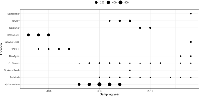
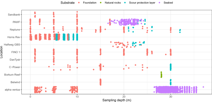
Due to the different purposes of the projects from which the data originate, and the various construction periods of the artificial structures, there is variation in the number of samples and the timing of sampling and water and sediment depths at which the samples were taken. The total number of samples per location varied from 11 (Borkum Reef) to 1,984 (alpha ventus; Fig. 3). Sampled water depths varied between 0 and 37 m, and some structures were sampled throughout the water column (e.g., FINO 1, Neptune, Horns Rev), while at some locations only the top half of the water column was sampled (e.g., alpha ventus; DanTysk, Sandbank; Fig. 4).
Substrate sampled per location and depth. To illustrate variations in the number of samples and variations in substrates at locations at the same depth, a small amount of random noise (jitter) was added to the positioning of the points in the x and y direction. To illustrate variations in the number of samples and variations in substrates at locations at the same depth, a small amount of random noise (jitter) was added to the positioning of the points in the x and y direction.
BISAR is a valuable dataset to investigate the colonising epifauna on different artificial structures and the benthos surrounding the structures. Descriptions and details about the study designs, including reference sites for the different artificial structures, are given in Table 1 (see column DOI (Related papers)). The currently unpublished BISAR collection has already been used in scientific studies e.g., to estimate the effects of decommissioning of offshore wind farms on benthos43; to investigate long-term cumulative impacts of offshore wind farms on biodiversity44; and some of the data have been applied to compare biodiversity on platforms, wind farms and rocky reefs27 and in the analysis of generalised benthic changes after wind-farm construction19. These published studies highlight the potential application of the BISAR data collection.

