ML integrated with spectral indices for mangrove mapping
In this study, the ML classifiers RF, SVM, GB and the ensemble approach were employed for mangrove mapping using Landsat 8 Surface Reflectance (SR) OLI/TIRS data, covering the period from January to December 2023 on Farasan Island, Saudi Arabia. Data collection and processing were conducted within the Google Earth Engine (GEE) environment. Although deep learning models like CNNs are useful for mangrove classification, they were not used in this study due to the requirement of frameworks (e.g., TensorFlow, PyTorch), which Google Earth Engine does not support36. This study emphasizes the utility of spectral indices such as the NDVI, MNDWI, SR, GCVI, and LST. This approach of using spectral indices offers significant advantages over traditional methods such as land use/land cover (LULC), field surveys, and supervised classification. By leveraging the unique reflectance characteristics of mangroves, spectral indices enable more accurate and detailed classification, particularly in detecting scattered and low-density patches.
The proposed method achieved high overall accuracy (OA) and kappa coefficient (KC), demonstrating its effectiveness for mapping mangroves in remote areas such as Farasan Island, where extensive fieldwork is challenging. This approach is particularly valuable when ground truth data are difficult to obtain due to logistical constraints. While reference samples derived from high-resolution satellite imagery using Google Earth through visual interpretation are widely used, this technique can introduce uncertainties, especially in areas with high chlorophyll concentrations that may obscure mangrove boundaries37. In such cases, overlaying NDVI data proved highly beneficial, as the NDVI effectively distinguishes vegetation health and density, reducing misclassification and improving the accuracy of mangrove delineation38.
One of the key advantages of using spectral indices is their ability to detect mangroves with varying vegetation densities, including low-density and dispersed patches. This phenomenon was demonstrated in research by Pham et al. (2020), who showed that machine learning (ML) algorithms combined with spectral indices outperformed traditional land use/land cover (LULC) mapping in terms of accuracy and precision, particularly in complex ecosystems such as mangroves39. By integrating spectral indices, that capture vital information about vegetation health (NDVI), water content (MNDWI), and thermal properties (LST), the proposed approach provides a multidimensional understanding of mangrove ecosystems. This capability surpasses LULC maps, which often rely on broad land cover categories and fail to capture the subtle distinctions between mangrove and nonmangrove areas.
The application of an ensemble of ML models (RF, SVM, GB) enhances the robustness of the classification. As demonstrated by recent studies40, combining different models improves classification accuracy and minimizes errors, particularly in complex environments where single models may fall short. For example, in this study, the ensemble method produced an overall accuracy of 92.2%, outperforming individual classifiers such as RF (91%) and SVM (89%). This result underscores the superiority of using ensemble techniques in conjunction with spectral indices for detailed and accurate mangrove mapping.
Landsat 8 (SR) compared with other satellite data for mangrove classification
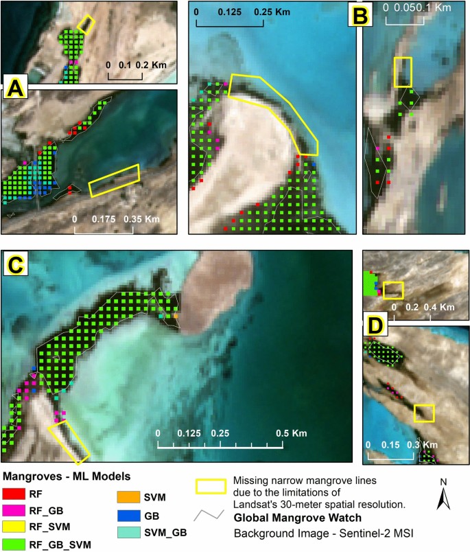
Landsat 8 Surface Reflectance (SR) OLI/TIRS data, with a 30-meter spatial resolution and a 16-day revisit cycle, provides a good balance between spatial detail and temporal frequency, making it well suited for ecosystem monitoring in remote areas such as the Farasan Islands. However, compared to Sentinel-2, which offers a finer 10-meter resolution, Landsat 8 may miss narrow and linear mangrove patches, as shown in yellow polygons (Fig. 8).
Illustration of missing narrow mangrove (highlighted in yellow polygons) due to the limitations of Landsat’s 30-m spatial resolution. The classification results from multiple machine learning models (Random Forest [RF], Gradient Boosting [GB], Support Vector Machine [SVM], and Ensemble) are displayed over Sentinel-2 MSI imagery for sites A, B, C, and D, showing the impact of spatial resolution on mangrove mapping.
The higher resolution of Sentinel-2 allows for better detection of smaller vegetation structures41. Additionally, Sentinel-2’s five-day revisit cycle is significantly shorter than that of Landsat 8, making it more effective for detecting short-term environmental changes, which is crucial for monitoring dynamic ecosystems such as mangroves that may undergo rapid alterations due to environmental factors or human interference42. But, Sentinel-2 imagery lacks thermal bands, which limits its ability to capture the thermal properties of mangroves43, an essential aspect for differentiating mangroves from surrounding land and water environments. Mangroves are typically situated in complex transitional zones between land and water, where thermal data can provide valuable insights. Landsat 8’s Thermal Infrared Sensor (TIRS) plays a critical role in detecting these thermal variations, making it more suitable for comprehensive mangrove assessments, particularly in regions where land–water interactions are prominent44. Research has shown that mangrove areas often exhibit unique thermal properties due to their intertidal location and proximity to water bodies, which makes LST a valuable tool for monitoring these ecosystems45. Additionally, Landsat 8 benefits from atmospheric correction algorithms such as the Landsat surface reflectance Tier 1 product, which improves data quality by minimizing atmospheric interference, especially in regions such as the Farasan Islands, where arid conditions and coastal dynamics can affect image clarity46. In contrast, Sentinel-2, despite its finer resolution, is more prone to atmospheric contamination in areas with persistent cloud cover47.
Very high-resolution datasets, such as GeoEye and SPOT, provide even greater spatial detail, with resolutions as fine as 0.5 meters. This makes them excellent for capturing fine-scale variations in mangrove ecosystems and detecting smaller, fragmented patches that may be missed by Landsat or Sentinel imagery. However, these high-resolution datasets have significant limitations. First, they are expensive, especially for large-scale or long-term monitoring projects48. Second, their availability is typically limited to specific areas, and they do not provide regular global coverage, making them unsuitable for continuous monitoring or time series analysis49. Moreover, high-resolution data sources such as GeoEye and SPOT are not integrated into cloud-based platforms such as GEE, which limits their utility for large-scale automated analysis. The absence of thermal bands in these datasets further restricts their application in studies that require LST data, which is essential for assessing mangrove health and environmental stress50. These factors make high-resolution datasets less practical for operational monitoring, despite their superior spatial detail.
Model performance and results comparison with global mangrove maps
The classification results show variability in mangrove area estimates across groups and models, reflecting the strengths and limitations of each. The RF model identified the largest total mangrove area (4.92 km2), outperforming SVM (4.76 km2) and GB (4.56 km2), while the ensemble model provided an estimate (4.78 km2). The scattered and fragmented nature of mangroves on Farasan Island poses challenges, particularly in low-density patches, where model misclassifications occurred. Additionally, medium-resolution Landsat 8 data limit the detection of fine-scale mangrove features, impacting boundary accuracy. In this study, biases were mitigated by adding training samples at locations where mangroves existed but were not initially classified. This approach helped improve model sensitivity to low-density and fragmented patches, reducing misclassification errors.
The RF model’s superior performance is supported by its highest F1-scores for mangroves as well as for nonmangroves, outperforming both GB and SVM in these categories. The robustness of an RF can be attributed to its nature, which minimizes overfitting by aggregating decisions from multiple decision trees, leading to better generalization. In the independent accuracy assessment, the RF model achieved the highest overall, User’s and Producer’s accuracies for the mangrove class. This finding indicates that the RF effectively balances precision and recall, reducing classification errors. The RF model was the most reliable, consistent with findings from other studies51,52,53,54. On the other hand, SVM and GB, achieved lower accuracies. RF’s ability to handle complex, nonlinear relationships between spectral indices and mangrove presence, along with its resilience to noise, makes it more reliable for mangrove mapping. This highlights the importance of using models like RF for ecological applications where accurate vegetation classification is crucial.
Comparing our results with global mangrove datasets helps highlight the strengths and limitations of the study. The Global Mangrove Watch (GMW) datasets feature a spatial resolution of ~25 meters, derived from multi-sensor satellite data. ALOS PALSAR radar (25m) enables cloud-penetrating mangrove structure mapping, while Landsat optical imagery (30m) supports spectral analysis of health and extent. We used 30-meter Landsat 8 (SR) data, deriving multiple spectral indices for input into machine learning classifiers, which allowed for more localized and detection of dispersed mangrove patches. Figures 6 and 7 illustrate the classified mangrove areas, highlighting the additional extents identified by our ML approach. We also compared our results with the Global Mangrove Forests Distribution, 2000 dataset55, which used hybrid supervised and unsupervised classification techniques on Landsat-5 imagery at 30m spatial resolution, finding that it estimated a significantly lower mangrove area for the Farasan Island region than our ensemble model.
These findings suggest that while global datasets offer valuable insights into large-scale mangrove distribution, local assessments using region-specific data are essential for accurately quantifying mangrove extent. This is particularly important in arid coastal regions such as Farasan Island, where mangrove ecosystems are scattered and sensitive to climate change.
Novel contributions relative to existing mangrove study in Saudi Arabia
Compared to the study conducted in the Asir region56, which focused on large-scale mangrove mapping and identifying priority reforestation areas based on spectral index trend analysis, this study emphasizes the fine-scale classification of fragmented mangrove patches in an island ecosystem, a geomorphologically and ecologically distinct setting where detection is often hindered by ecological heterogeneity. This locally calibrated approach addresses critical gaps in global assessments and supports more targeted conservation efforts in Saudi Arabia’s protected island ecosystem.
Future research directions
Given the critical role of mangroves in protecting Saudi Arabia’s coastal ecosystems, future research should focus on assessing the long-term impacts of climate change on mangrove health and identifying potential restoration strategies. One promising direction is leveraging multi-source remote sensing (e.g., Sentinel-1 SAR, ICESat-2 LiDAR) to analyze changes in mangrove biomass and canopy structure. Developing AI-driven mangrove restoration plans using deep learning to model optimal seedling survival rates under different hydrological and climatic conditions could revolutionize large-scale mangrove rehabilitation efforts, ensuring long-term sustainability.


